


News
Share
Published 09:33 29 Sept 2019 BST
Explore more on these topics:
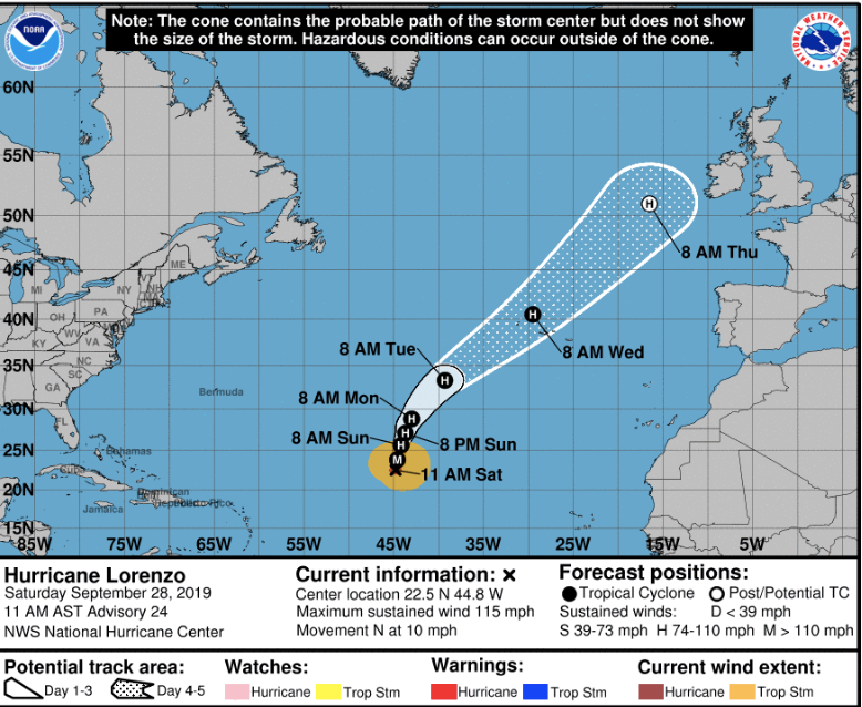 On Sunday morning, the National Hurricane centre categorised Lorenzo as "an extremely powerful category 5 hurricane. It is the strongest hurricane on record this far north and east in the Atlantic basin" but Met Éireann said that there's some uncertainty around its path.
"The latest National Hurricane Centre forecast shows the hurricane bending gradually towards Ireland but with a margin of uncertainty around its track," they stated.
https://twitter.com/NHC_Atlantic/status/1178141240816070656
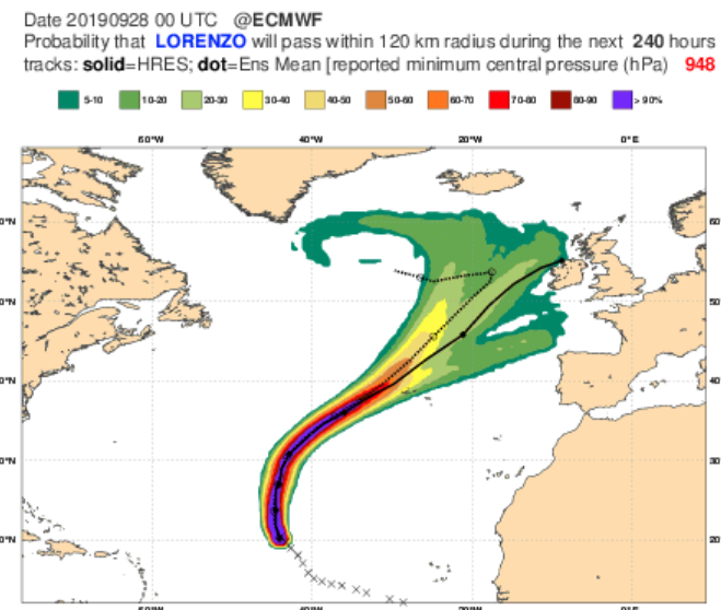
The European Medium Range forecast model that Met Éireann use shows a larger spread once it comes nearer this side of the Atlantic.
They state: "This indicates that there is a great deal of uncertainty on whether it will impact Ireland. This model calculates 50 possible solutions, all starting with slightly different initial values of its track to reflect the uncertainty of its future track. The black line in this graphic (below) shows the forecast track of the current computer model run, and the colours indicate all the other possible tracks in the ensemble of 50 members."
At the present moment, they've stated that if Hurricane Lorenzo does reach Ireland, it will likely arrive on Thursday and Friday.
In terms of the weather forecast for those days, Met Éireann state that "there is potential for unsettled weather to develop during this period. However, uncertainties in the detail remain due to the track of Lorenzo for this timeframe. It is likely to become milder due to the influence of tropical origin air."
Met Éireann is closely monitoring the progress of Lorenzo in the south Atlantic.
On Sunday morning, the National Hurricane centre categorised Lorenzo as "an extremely powerful category 5 hurricane. It is the strongest hurricane on record this far north and east in the Atlantic basin" but Met Éireann said that there's some uncertainty around its path.
"The latest National Hurricane Centre forecast shows the hurricane bending gradually towards Ireland but with a margin of uncertainty around its track," they stated.
https://twitter.com/NHC_Atlantic/status/1178141240816070656
The European Medium Range forecast model that Met Éireann use shows a larger spread once it comes nearer this side of the Atlantic.
They state: "This indicates that there is a great deal of uncertainty on whether it will impact Ireland. This model calculates 50 possible solutions, all starting with slightly different initial values of its track to reflect the uncertainty of its future track. The black line in this graphic (below) shows the forecast track of the current computer model run, and the colours indicate all the other possible tracks in the ensemble of 50 members."
At the present moment, they've stated that if Hurricane Lorenzo does reach Ireland, it will likely arrive on Thursday and Friday.
In terms of the weather forecast for those days, Met Éireann state that "there is potential for unsettled weather to develop during this period. However, uncertainties in the detail remain due to the track of Lorenzo for this timeframe. It is likely to become milder due to the influence of tropical origin air."
Met Éireann is closely monitoring the progress of Lorenzo in the south Atlantic.
 Main image via Carlow Weather
News

News

News

News
Celebrities to descend on Dublin for Dior fashion show in Trinity College
Derry man Jonathan Anderson is coming home to Ireland with plans to stage his first fashion show in Ireland this winter. The Irish designer plans to unveil his Dior pre-fall 2027 collection at Trinity College in Dublin on December 4th. Anderson’s first job in fashion was in Brown Thomas in Dublin, and he has collaborated with brewer Guinness under his J.W. Anderson label, […]
News
15h
Two officers in hospital and Garda station shut after incident with cannabis vapes
Two gardaí who were handling seized cannabis vapes were rushed to hospital on Wednesday. The incident at Edenderry Garda Station in Co Offaly yesterday afternoon sparked a major security alert and the temporary closure of the station. A specialist deep clean is due to take place today. The two men were rushed to hospital with […]
News
16h

News
Housing crisis in Ireland summed up by these unbelievably bad property listings
News


