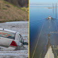
There are concerns that winds could get as high as 15o km/h this weekend.
While it has not been confirmed yet, some weather forecasters are predicting that Storm Callum is to arrive in Ireland later this week.
At the moment, Met Éireann have stressed that this is an advisory, not a warning, and that if any full warnings will be issued in due course as is necessary.
The weather advisory was issued on Tuesday afternoon:
“A spell of wet and very windy, possibly stormy, weather is expected on Thursday night/ Friday morning as a deep depression tracks Northwards to the West of Ireland. There is the risk of coastal flooding due to high tides and surge,” the advisory read.
“Later Friday and continuing into Saturday there is the potential for some high totals of rainfall and flooding due to another area of low pressure and series of weather fronts, with the East and South particularly at risk.”
As it stands, the advisory will remain in place from 11pm on Thursday night until 9pm on Saturday night.
On the other hand, Midlands Weather Channel have described it as an imminent “Weather Bomb”, which sounds all kinds of scary:
“The overnight model updates continue to show storm Callum maintaining its projected track and intensity, and developing into one of the most powerful low-pressure systems in quite some time. Pressure readings from Callum are expected to dip to as low as 950 hPa, which is exceptionally low indeed,” the Midlands Weather Channel forecast reads.
“The term “bomb” is used meteorologically to describe a system which experiences a drop of 24 hPa in less than 24 hours, otherwise knowns as rapidcyclogenisis. Callum is expected to drop by 32 hPa inside a 24 hour period.
“Windspeeds are projected to reach up to 150km/h in western coastal counties, with some gusts even approaching 160km/h depending on the storms track and when it reaches it peak intensity. Further inland across the remainder of the country winds are expected to reach as high as 130km/h possibly up to 140km/h in exposed places.
“Coastal flooding is also likely to become a major issue, particularly across southern and western coastal areas, with Cork and Galway in particular looking vulnerable due to high Spring tides.
“Callum looks to be a very serious storm, and therefore staying up to date with the latest developments is advised.”
LISTEN: You Must Be Jokin’ with Aideen McQueen – Faith healers, Coolock craic and Gigging as Gaeilge