


News
Share
Published 09:27 7 Feb 2014 GMT
Updated 13:29 12 Nov 2014 GMT

#TV3Weather Brace for #StormRuth impact later on this eve. Winds gusting 80-100kph. High seas & tides. Flood alert ⚠ pic.twitter.com/1DPQK33rMx
— Deric Ó h'Artagáin☀☔ (@deric_hartigan) February 7, 2014
However, a quick look at our friends at Met Eireann shows that a much more destructive storm will land on the country on Monday night/Tuesday morning. The wind map below illustrates that perfectly.
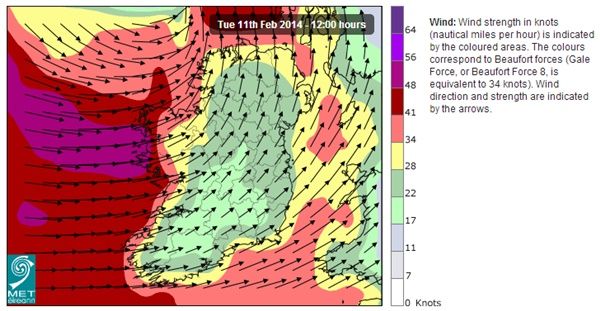 The forecasters say that 'very stormy conditions' will arrive early on Tuesday, followed by 'very severe and damaging winds' later that day. This, of course, will be accompanied by 'heavy rain' too.
Getting really tired of your sh*t now Mother Nature
The forecasters say that 'very stormy conditions' will arrive early on Tuesday, followed by 'very severe and damaging winds' later that day. This, of course, will be accompanied by 'heavy rain' too.
Getting really tired of your sh*t now Mother Nature
News

News

News

News

News

News


