Weather warnings have been issued
Winter-dwellers in Ireland (that’s us!) and the UK are bracing themselves for a new Arctic blast, with a huge swathe of snow set to land early next week.
The Met Office has warned of ‘colder than average weather for the time of year’ with ‘a marked reduction in rainfall amounts following a wet start to January’. The reports and charts line up with a prediction from Met Eireann for next week.
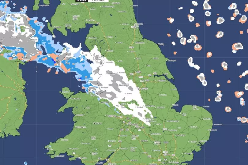
Maps show a huge cloud of snow set to hit Northern Ireland and the north of England on Monday 15 January, with an ‘Arctic influence’ falling over the whole island. The cold temperatures will continue into Tuesday, with it not expected to warm up again until later the week.
Met Eireann on “wintry showers” while Met Office say potential for “heavy snow”
Met Eireann forecaster Linda Hughes, looking at the next five days, stated, “Some sunny spells will develop through [Sunday], with just isolated showers.
“Highest temperatures of 4 to 7C in a light to moderate northerly wind. Monday will be cold with frost slow to clear.”
It is that band of colder air that is most likely to bring the wintry showers and potentially heavy snow – southern Ireland is tracking to avoid the biggest chill but many parts of Ulster and northern England are in line for it, going off current charts:
All models now have cold air moving down from North again on Sunday into Monday. The depth and length of this cold spell is less clear but next week could be a cold week, chances of snow in South reduced but could still see wintry falls, especially in Northern areas. pic.twitter.com/Bajl4EIMcI
— Carlow Weather (@CarlowWeather) January 10, 2024
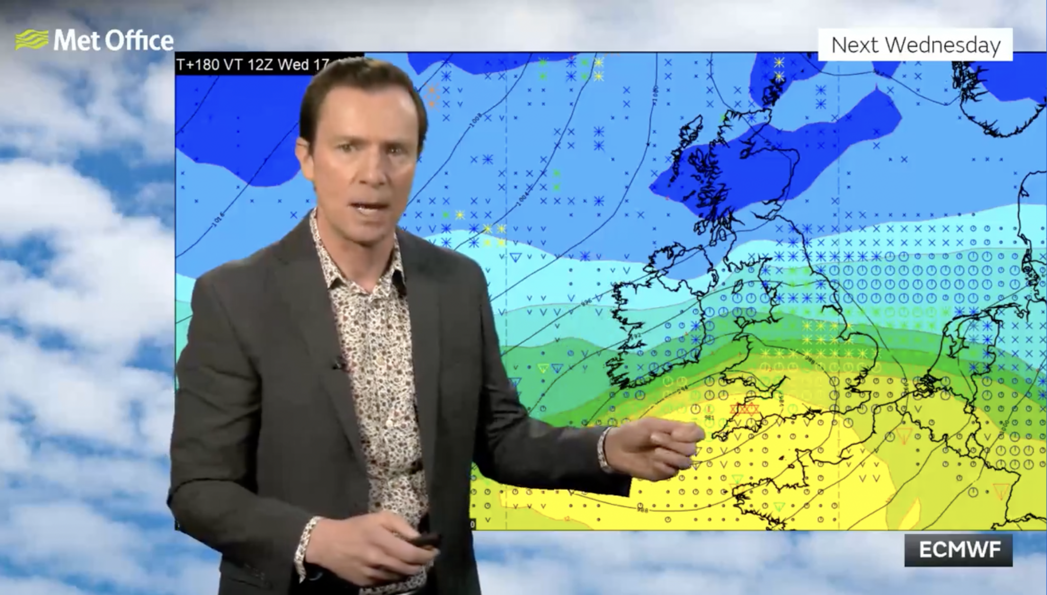
Alan Deakin, a meteorologist with the Met Office, posted a video with the 10-day trends and predicted that chances of snow could hold for a few days with Wednesday, January 17 a strong contender.
“It could be a juicy one.” he introduced his video, “especially if you’re interested in snow.”
Interestingly, he showed the difference between European and American weather tracking charts. There were slight discrepancies in the American [Global Forecast System – GFS] and European [European Centre for Medium-Range Weather Forecasts – ECMWF] models but both seemed in agreement that snow was likely in the middle of next week.
Northern Ireland may experience the heaviest dusting but it will be noticeably cooler across the entire island.
In the image [below] the * indicates snowfall – Dublin is included here, next Wednesday [Jan 17].
Things will turn colder again over the weekend. ❄️ Next week could see some more widespread and potentially heavy snow but details at this range are uncertain.
Watch the full 10 day trend for more 👉 https://t.co/mCWPAamOCj pic.twitter.com/n3E4kxSl00
— Met Office (@metoffice) January 10, 2024
Met Office meteorologist Aidan McGivern said: “A cold front from the north towards the weekend will mark another change in the airmass for the UK, moving from something with a bit of an Atlantic influence to air that comes more directly from the Arctic.”
He continued: “We start with a northerly airflow and snow showers, especially near the coasts in the north. But there will also be brighter skies for some. Then, from the middle of next week, low pressure tries to move in from the South West, and the impact of this is still a bit uncertain at this range.
“Different models are saying different things in terms of the track of this low, but you have the ingredients for snow with cold air in place and additional moisture supplied from the Atlantic, which will bring rain, but on the boundary with the cold air, you could see some snow.”
Related articles:
- Dublin city centre street closed down due to drugs and crime
- Ireland braced for more freezing conditions as parts of country see snow
- Graham Norton says being stabbed ‘changed his life for the better’
- Over 21,000 Irish citizens granted working holiday visas to Australia, double from the previous year
LISTEN: You Must Be Jokin’ with Aideen McQueen – Faith healers, Coolock craic and Gigging as Gaeilge