








News

Share
Published 11:15 28 Aug 2026 BST
Updated 11:45 28 Aug 2026 BST
Status Yellow and Orange rain warnings were in place for several Irish counties last night and earlier this morning, though not in Laois where the music event takes place in Stradbally every year.
Though Laois may have escaped weather alerts, reports from festivalgoers posted on social media paint a grim picture.
Many EP attendees travel to the festival on Thursday night, so they have more time to set up their tents and get comfortable.
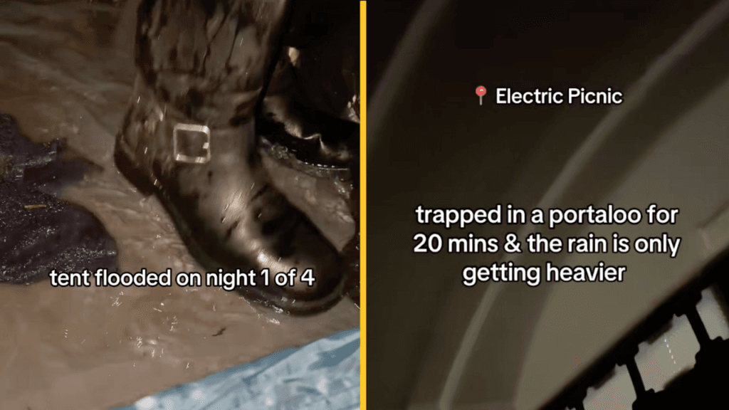
This year, however, we're already seeing footage recorded of leaky tents and someone becoming "trapped in a portaloo".
You can watch some of these videos for yourself below:
It doesn't sound like the rest of the weekend will be much better for those camping at Electric Picnic.
As weather experts outline, there won't be much escape from the rain.
You can read Met Éireann's current forecast below:
There will be rain in the east and southeast at first this morning, with patches of drizzle, mist and fog elsewhere.
The rain will clear later this morning and sunny spells will improve this afternoon, although some showers will develop too, turning heavy at times.
Cloud will increase across the southwest this evening. Warm and humid with highest temperatures of 18 to 23 degrees, in a light to moderate west to northwest breeze.
Conditions will become wet on Friday night as rain spreads from the southwest, reaching Ulster towards morning.
The rain will be heavy at times and may cause localised flooding. Isolated thunderstorms are also possible.
Winds will be mostly light and variable but will increase moderate to fresh northeasterly in the southwest later. Lowest temperatures of 11 to 15 degrees.
Saturday morning will start cloudy and wet with widespread rain, heavy at times.
The rain will gradually clear eastwards from most areas through the morning and early afternoon, with isolated showers and some brighter spells following.
But the cloud and rain will linger in parts of the east for much of the day. Highest temperatures of 15 to 20 degrees with light to moderate north to northwest winds.
Early Saturday night will be mostly dry, with clear spells and just isolated showers.
Overnight, cloud will increase and more frequent showers will develop in the south and west, turning heavy at times.
Lowest temperatures of 11 to 15 degrees with light to moderate south to southeast or variable winds.
Sunday will start cloudy and wet as rain spreads northeastwards across the country, turning heavy and possibly thundery at times.
The rain will gradually clear northeast through the day, followed by sunny spells and scattered showers.
Highest temperatures of 15 to 18 degrees with moderate to fresh winds, variable in direction.
It will become breezy on Sunday night with a mix of clear spells and scattered showers, merging to longer spells of rain at times.
Lowest temperatures of 11 to 14 degrees with moderate to fresh westerly winds.
Images via jackcarrieman and caoimha.lp/TikTok
Explore more on these topics:
Electric Picnic (EP) kicks off today (Friday, 28 August). Yet after an Irish summer of uncharacteristically sunny and warm weather, conditions this weekend are far from ideal for camping and outdoor gigs.

News

News

News
News
Robert Pether reunites with family in Ireland after being detained in Iraq for five years
The Australian engineer had been held in Iraq since April 7, 2021. Robert Pether has returned to Ireland and reunited with family after being detained in Iraq for five years. Australian engineer Robert Pether was detained in Iraq in April 2021 on fraud charges linked to a contract dispute between his employer and the Central […]
News
55 min
Further calls to stop Ireland – Israel game in Wheelchair Basketball Championships
Calls are mounting for the Irish Wheelchair Association to cancel their game against Israel on Wednesday. The Irish Wheelchair Association (IWA) are due to play Israel in the Women B division European Championship on Wednesday this week, despite opposition to the game. First reported by JOE in August, it has since emerged the IWBF granted […]
News
2h

News
News